In the early Middle Ages, if you traveled from Paris to Rome, once you crossed the Rhône River at Lyon, you were no longer in France, but in French-speaking principalities that were component parts of the Holy Roman Empire. After 1349, the first of these you’d encounter on crossing the river, the Dauphiné, was property of the kings of France—though arguably not fully a part of France, legally, until much later. After about a day’s travel, the next principality you would pass through, Savoy, remained part of the Empire until the end of Ancien Régime, and even beyond, not becoming part of France until 1860. This drive, which I did about four years ago, will circle through these two fascinating formerly independent principalities, and also takes a quick look in at a third principality, the curious micro-state of Dombes that remained legally independent of France well into the 18th century. I will also pay a visit to one of the most beautiful buildings in Europe, the Abbey of Brou, in the alliteratively named town of Bourg-en-Bresse.

All of these regions had once been part of an ancient kingdom created by the Burgundians, a Germanic tribe who settled the region in the 5th century. This once encompassed what is now western Switzerland, the Burgundy you’ve heard of, and the Burgundy you haven’t, today’s regions of Dauphiné, Savoy and Provence. These two Burgundies became divided into Transjurane and Cisjurane Burgundy in the 9th century, the former meaning ‘across the Jura Mountains’ and the latter ‘on this side’ (looking at it from the perspective of Lyon or the lower Rhône Valley, so sometimes called Upper and Lower Burgundy, respectively). Both were at various times blended with the kingdoms of Arles and Provence, which expanded and contracted over the centuries, until disintegrating in the middle of the 11th century. The Holy Roman Emperor, suzerain of this whole area at the time, granted lands in the former kingdom to local lords as fiefs, Savoy emerging from part of Transjurane Burgundy and its neighbour to the south, Dauphiné evolving from parts of Cisjurane Burgundy. It’s very confusing, and in fact remained confusing for a long time, with the borders ill defined and the rulers of Savoy and Dauphiné continually fighting over them. To add to the confusion, several of the ancient towns in the region remained outside the jurisdiction of either prince, as autonomous territories ruled by bishops, like Geneva, and it is here where this driving tour begins.

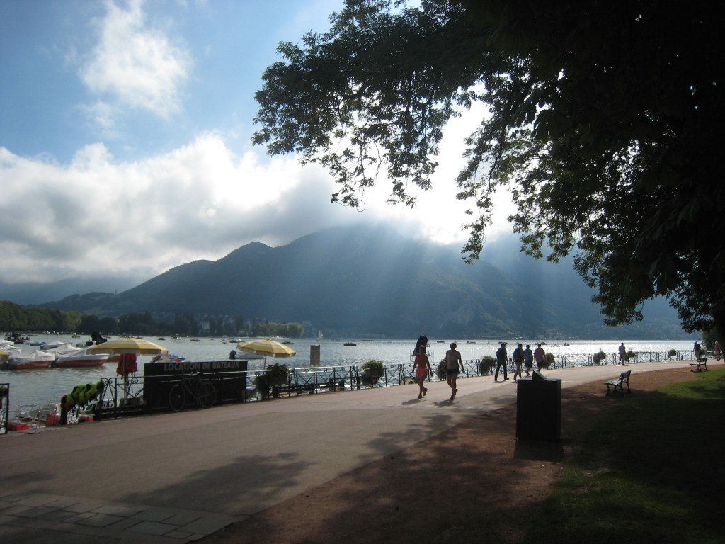
I landed at the airport in Geneva and rented a car on the French side (an interesting enclave of car rental desks), then drove along an eerie fenced corridor from the airport to the town of Ferney in France, so as not to have to go through Swiss territory and pay the exorbitant rate to drive through (well, mostly under) the city of Geneva. I went all the way around the bowl in which Geneva sits—with lovely views of the city, the lake and the surrounding mountains—till I arrived at a cheap hotel I’d booked in Archamps. The car park had a sign at the end of it saying ‘Frontière’, so I naturally jumped back and forth across, in and out of Switzerland, without impunity. The next morning I drove the short way over a low pass to the town of Annecy. It’s not a long drive, and it is interesting to come to it from the direction of Geneva, as it can put in mind the distance (physical and mental) between that city and the seat of its Catholic bishops after 1535—the year they were sent away from a now Calvinist city.
Annecy is a beautiful small town, kept small as it is hemmed in by the waters of Lake Annecy and the surrounding mountains. A short river, the Thiou, flows out of the lake and into the river Fier which soon joins the Rhône a few miles to the west. The Thiou bisects the town, also criss-crossed by canals. The streets are lined with shops and restaurants, and the day I was there, absolute hordes of tourists. Picturesque bridges cross the waterways, jammed with those making photos, especially in favour of the town’s most famous landmark, the Palais de l’Isle, a 12th-century fortified building on an island in the centre of town that has served as Annecy’s prison and courthouse.

I made a quick exit from the town centre and headed up a small hill towards the Château d’Annecy. The oldest part of this complex of buildings, built at various times and in various styles, was the residence of the counts of Geneva—forced to leave the city of Geneva itself by its prince-bishops in the early 13th century (rather ironically, eh?)—until their extinction in 1394. Their castle and their county (the Genevois) were then sold to the counts of Savoy in 1401. These counts emerged in the mid-11th century as loyal agents of Imperial power in the strategic valleys leading up to the key Alpine passes between France and Italy. By the 1100s, they owned lands on both sides of Alps: Savoy, Maurienne, Chablais on one side, and Aosta and Torino on the other, in the Italian Piedmont. In the 14th century, the Savoyard counts expanded their rule southwards, acquiring the county of Nice and thus an outlet to the Mediterranean, and with this addition of Annecy and the Genevois, their power stretched from Lake Geneva to the sea.
The counts of Savoy were based in Chambéry (see below), so they therefore left younger brothers or cousins in charge in Annecy and created the apanage of Genevois (an apanage is a segment of a kingdom or noble territory sectioned off for use by a younger brother, but still remaining part of the family patrimony). First counts, then (from 1564) dukes, these apanagistes rebuilt parts of the Château of Annecy in the 15th and 16th centuries, notably in the 1570s when the castle provided a refuge from French court politics for Jacques de Savoie, the Duke of Genevois (aka the Duke of Nemours, his title in France), and his powerful Italian-born wife, Anne d’Este, formerly Duchess of Guise. One of the main wings of the castle today bears the name Nemours and tells their story, with contemporary objects, artworks and furnishing. When the line of dukes of Savoy-Nemours became extinct in 1659, the castle at Annecy fell out of favour, and was used as a barracks for the next centuries until it was turned into the city museum after the Second World War. Today it houses various galleries about history, local artists and the natural world.

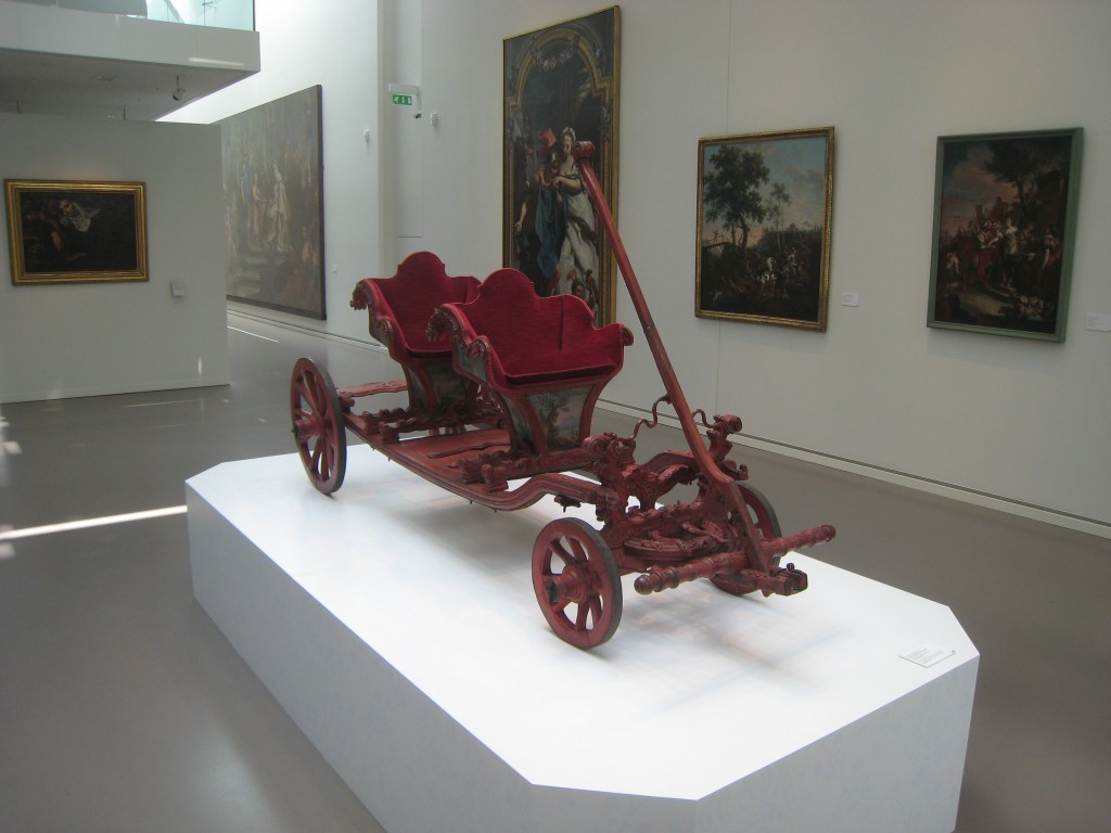
I left Annecy after lunch and drove south, skirting the main mountain range of the pre-Alps which towered over the lake to the east—Albertville, for example, is not far, and the land of winter sports and site of the 1992 Winter Olympics. I soon arrived at another lake, Lac du Bourget, and the resort town of Aix-les-Bains. At the southern end of the lake is the city of Chambéry, the capital of the counts of Savoy from the 1280s, improved by them once their status was raised to dukes by Emperor Sigismund in 1416, then mostly abandoned once their court moved across the Alps to Turin in 1563. The court stayed at Chambéry only occasionally after that—sometimes when hosting visiting French royal relatives—or its castle housed unwanted dowagers or abdicated dukes. I parked my car in the centre of town and noticed the castle wasn’t open till later in the afternoon—and it was boiling hot—so I went into the local art museum and discovered with great luck that it currently was hosting an exhibition about the court of Turin as patrons of the arts! A lovely centrepiece was a lovely red baroque wagon for the royal children of the House of Savoy.
Later I went on a guided tour of the castle of Chambéry, which is monumental in scale but a bit of a hodge-podge of architectural styles, including a gorgeous Gothic chapel with a distinctly Jesuit façade slapped onto it. One detail you can see all over buildings such as this is the ‘Savoy Knot’, a symbol of the dynasty also used as an emblem for their chivalric Order of the Annunciation, founded in 1362 by Count Amadeus VI.

This order of knighthood became a royal order after 1713 when the dukes of Savoy were promoted to kings of Sardinia (and later the royal house of Italy). One of these kings, Victor Amadeus III, returned to Chambéry and tried to make it look more appropriately regal by adding a new wing, which today is the seat of the government of the Département de Savoie. After 1860, Savoy was ceded to France, and rather than being the second city of a trans-Alpine monarchy, Chambéry settled into life as a quiet provincial town. I enjoyed a meal that included some regional specialisms like the of tartiflette, made from potatoes, bacon (lardons), onions, and local reblochon—the famously stinky Savoyard cheese. My stay overnight here was not very memorable…but the real star of the show was revealed the next day!
I got up early as I knew I had a lot of driving to do. Heading back north, this time I went to the west of the lake and turned off the main road onto a tiny mountain road. For the next hour I climbed and climbed, twisted and turned round sharp hairpins, then rapidly descended back down to the edge of the lake.

Here on the lake’s edge was the Abbey of Hautecombe, founded for the Cistercian Order by Count Amadeus III of Savoy in the early 12th century, and resting place of counts and dukes of his dynasty ever since. A place of real beauty in the most wonderful location on this lake surrounded by steep mountains, it had fallen into disrepair during the French occupation of the 1790s, but was rebuilt by King Charles Felix of Sardinia in the 1820s, and his tomb forms one of the Abbey’s centrepieces. The most recent royal burials were of former King Umberto II of Italy in 1983, and his wife Queen Marie José at his side in 2001. Since the 1990s, the Abbey has been owned and run by an ecumenical Catholic regeneration group known as Le Chemin Neuf. Imagine my surprise when I listened to the English audio guide and immediately recognised the voice of an old friend who had lived in this community a few years before!

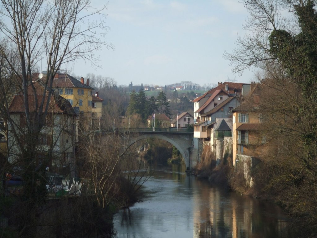
Luckily the road back out of Hautecombe was less harrowing, and I drove around rather than over the ridge of the Mont du Chat then joined the road that accompanies the mighty Rhône river as its squeezes through some pretty dramatic gaps in the southernmost Jura mountains (roughly where transjurane and cisjurane were demarcated). I paused for lunch and a bit of a nose round in the town of Belley, which was once the capital of a small province known as Bugey, sold to France by the Duke of Savoy in 1601. Not a large town, it was nevertheless the seat of a bishop, so had its own small cathedral, mostly rebuilt in the 19th-century neo-gothic style, in front of which I sat and munched my favourite mid-afternoon snack, coffee-flavoured éclair. Now you know what to bring when I host a dinner party.
I continued to follow the road alongside the Rhône—with water still that curious light blue-green colour you see when the river leaves Lake Geneva to start its long journey to the Mediterranean—and crossed the ancient frontier between Savoy and the Dauphiné at the river Guiers. I took a short detour up this river valley to twin towns both named Le Pont-de-Beauvoisin (‘the bridge of good neighbours’). This was the ancient crossing point of the river, where, at certain points in the past, royal brides were exchanged between France and Savoy, for example, Marie-Adélaïde de Savoie, married to the grandson of Louis XIV in 1696. Her wedding turned out not to be the cement for eternal friendship between the two states, and the girl’s father, Duke Victor Amadeus II, changed sides soon after when the next war started. Perhaps not a very good neighbour after all.
From Beauvoisin I left the Rhône valley and entered ‘France’ as it was until 1860, and the province of Dauphiné. I drove a short distance to the town of La Tour du Pin, where I stayed the next night. This town and its château, long since destroyed, was the centre of a large autonomous barony in the Middle Ages. The barons were at times completely independent of the Dauphins or else dominated the region as their most prominent vassals, until they themselves took over as Dauphin in 1282. The main line of the family became extinct only a few generations later, and sold the Dauphiné itself to the King of France in 1349, but various cadet lines continued into the modern era, and include one of the famous memoirists of the Revolutionary period, the Marquise de la Tour du Pin, born Henriette-Lucy Dillon, from a family of Irish Jacobites who had settled in France in the 1690s. This part of the Dauphiné, the Turripinois, took its name from the former barony, and is only one of several distinct regions that formed this territory, another former sovereign principality, like Savoy, that spanned from the Alps to the Rhône valley. Today it is divided into several modern départements, but in the past it was composed of regions, including those in the Rhône valley (Viennois, Valentinois), areas further inland (Diois, Grésivaudan), and fully Alpine territories further to the east (Gapençais, Embrunais, Briançonnais).
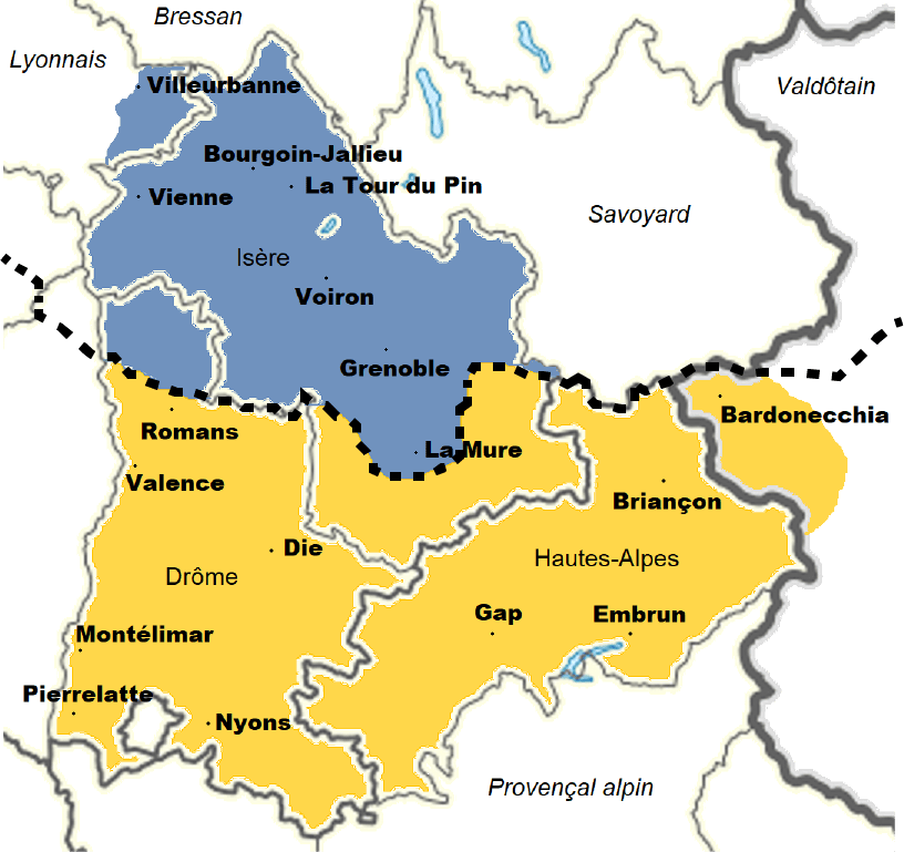
From La Tour du Pin, I continued the next day across the high arid plains (known as the ‘Terres Froides’) to the ancient Roman city of Vienne. This city gave its name to its surrounding countryside, the Viennois, and ultimately the full name of the medieval principality, the Dauphiné de Viennois. So what is the Dauphiné? Like Savoy, it was formed from the feudal possessions of one of the counts placed in charge by the Holy Roman Emperor when the Kingdom of Burgundy disintegrated in the 11th century. Originally titled counts of Albon, their citadel dominates a hill overlooking the Rhône valley a little bit to the south, about halfway between Vienne and Valence (the climb up to the ruins is worthwhile, but not on this trip). One of these at the start of the 12th century, Guigues, took the additional name ‘Dauphin’—the reasons for this are varied, complicated, and entirely conjectural—possibly, for example, because his mother came from the city of Taranto in southern Italy whose symbol was a dolphin. His successors were called ‘count-dauphin’ or simply ‘dauphin’. They soon shifted their base of operations from the area around Vienne further to the east, to the valley of the Grésivaudan, a much morphed form of ‘the valley of Gratianopolis’, the Roman city that became known as Grenoble. With Grenoble as their capital, the dauphins soon dropped the name ‘de Viennois’, and slowly expanded their control over the lands of Imperial bishops ruling in the deep Alpine valleys: Gap, Embrun, Briançon—as above.
I didn’t visit Grenoble on this trip, but it is certainly worth seeing in its dramatic mountain setting alongside the swift-flowing River Isère, and does complete the story of the Dauphiné, as its capital up until the division of the province into départements during the French Revolution. But today I was in the earlier capital, Vienne. Much remains to see of Roman ‘Vienna’, one of the most important of their outposts in Gaul, formerly the capital of the local Allobroges people. The city is built on several hills that slope down to the Rhône—a major river by this point, much larger than when I last saw it when leaving Savoy. One of the hills supports the ruins of a Roman theatre, and is now crowned by a massive 19th-century statue of the Virgin; the other dominant hill is topped by the medieval fortress that housed the archbishops of Vienne if politics got touchy in the town.


The archbishops of Vienne were powerful rulers in this region. Vienne has been one of the earliest centres of Christianity in Roman Gaul, and its bishops were elevated to archbishops as early as 450, giving them a claim to the title ‘Primate of the Gauls’, disputed with Lyon. As with most Imperial bishops, they maintained jurisdiction over their town and its surroundings that was quite separate from the rural feudal lords around them, in this case, the count-dauphins. And indeed, when the last dauphin, Humbert II, heavily indebted, sold the Dauphiné to the King of France in 1349, the archbishops of Vienne refused to give up their autonomy, not becoming fully part of France until the middle of the 15th century. The agreement between Humbert and King Philip VI stipulated that the territory should be ruled by the King’s son and heir, who was thereafter called ‘the Dauphin’, a tradition that persisted for the rest of the history of the French monarchy.

The next day, I drove north, skirting around the very large city of Lyon—itself attached formally to the Kingdom of France only a few years before the Dauphiné—and followed a bit further north the major tributary of the Rhône, the river Saône (they meet in the centre of Lyon).I stopped for lunch in a small town perched high on a hillside overlooking the Saône Valley: Trévoux.This town, with picturesque steep streets, and a crumbling ruined château, was once capital of a small micro-principality known as Les Dombes. In the Middle Ages it was the part of the lands held by the Lords of Beaujolais that were on the far side, that is, the Imperial side, of the river. These lords made the most of this sliver of land not under the jurisdiction of the king of France to exercise sovereign justice and mint their own coins. But it was never worth very much more than that, being a sandy, marshy terrain, a moraine filled with potholes which the locals filled with water to create a ‘pisciculture’, that is, raising fish (and frogs) to sell mostly to the citizens of the nearby big city of Lyon.

In 1400, the lordship of Dombes passed to the House of Bourbon-Montpensier, who continued to rule it as petty princes until the death of the last one, the duchess of Montpensier, better known as La Grande Mademoiselle, whose memoirs tell us of her thrill in visiting this small town where she, a junior member of the royal family, could act truly as a sovereign. As a sign of her grand benevolence—she was always quite the drama queen—she founded a hospital. But late in life she was forced to cede it to Louis XIV’s bastard son, the Duc du Maine. Although Maine spent most of his time at court in Versailles, he too enjoyed flexing his muscle as a sovereign, and constructed a parliament building, and most famously, a printing press, on which books could be printed outside the jurisdiction of the royal censors of France. The most famous series of books, the Dictionnaire de Trévoux, became famous as one of the major outlets for Enlightenment thought, disseminating views that might otherwise have been censored by the Crown. This came to an end in 1762, when Louis XV convinced his cousin, Maine’s son, the Comte d’Eu, to sell it, and the Dombes was finally integrated into the Kingdom of France


To end this drive, I started to head back east, vaguely towards Geneva. But I made one more overnight stop, in Bourg-en-Bresse. Driving diagonally right across the odd landscape of the Dombes, with its thousand small lakes, I arrived in this cute town, now considered part of Burgundy, but once the capital of another small semi-autonomous region, Bresse. Bresse was ruled by the dukes of Savoy from the 1270s, often given as the apanage to their heirs. In 1601, the Duke of Savoy ceded Bresse and Bugey (to the east, see above), to King Henry IV of France. Bourg as a town is nice to visit, with several streets lined with old houses belonging to merchants who thrived here, at an important crossroads between France and Italy. But the real treasure lies just outside the town, the Royal Monastery of Brou.

Brou had been the site of a monastery for many years, but in the early 16th century was re-founded as a royal necropolis for the House of Savoy by Margaret of Austria, widow of Duke Philibert II. Only Margaret, her husband, and his mother, are buried there—for as we have seen, the House of Savoy shifted its operations across the Alps into the Italian Piedmont in the next generation—but these tombs, and the building in which they are placed, are truly amongst the greatest artistic gems from this period of European history. The building is in stunning white, Flamboyant Gothic mixed with some newer Renaissance classical elements, and with a distinctive coloured glazed tiles, like those on the roof of the family Hospital in Beaune, in Burgundy, or even the cathedrals in Vienna and Budapest, a clear artistic link between the various outposts of the House of Burgundy and its successors, the House of Habsburg. Margaret herself was a link, as daughter of Emperor Maximilian and Mary of Burgundy, and successor to the dukes of Burgundy as governor of the Low Countries (she also left behind a wonderful palace in Mechelen, near Brussels). Margaret’s court in the Netherlands was famed as a place of patronage of writers, composers and painters, and she employed the finest craftsmen to construct her tomb here—both she and her husband are depicted twice, above and below, in effigies of marble and alabaster—and she hoped to retire here as abbess, in the tradition of Habsburg royal women. It was not to be however, and her nephew, Emperor Charles V would not let her leave her post as governor in the Low Countries, where she died in 1530.

From Brou I drove east on a twisting road across several low ridges and across the gorges of the River Ain, until I approached the gates of Geneva, at Bellegarde-sur-Valserine. Rather than using the motorway (something I have avoided this entire drive), you approach the Swiss border through a really dramatic gap in the Jura mountains, the Défilé de l’Ecluse, where the Rhône pushes its way through the mountains. I was still a bit early for my evening flight, so for one last oddity, I visited the small hillside town of Gex, once the capital of the smallest province of France, the Gexois, which was, like Bresse and Bugey, ceded to France by the duke of Savoy in 1601. There’s not a lot to see here—a supermarket where Genevans shop because the prices are much lower in France; and the heraldic oddity of a coat-of-arms that reflects that once upon a time, a long time ago, the barony of Gex was held by the lords of Joinville in far-off Champagne—so I headed towards the airport, noting that the next time I visited here I should tour the facilities of CERN, the nuclear research centre, and visit the château of Ferney, once home to the philosopher and playwright Voltaire. Border zones between kingdoms and empires are fascinating places to explore, zones of influence of different cuisines and artistic styles, good places to bring together international minds for scientific collaboration, and also good places to hide from the censors of 18th-century French theatre!

(images my own or from Wikimedia Commons)
